Difference between revisions of "Little Rock River Rail"
(→Streetcar History) |
|||
| (2 intermediate revisions by the same user not shown) | |||
| Line 1: | Line 1: | ||
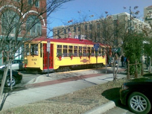
| − | [[Image:Trolley-winter.jpg|thumb|River Rail Trolley festooned for winter holidays. Photo by Phil Frana.]] | + | [[Image:Trolley-winter.jpg|thumb|300px|River Rail Trolley festooned for winter holidays. Photo by Phil Frana.]] |
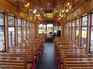
| − | [[Image:River-rail-interior.jpg|thumb|Interior of a River Rail streetcar. Photo by yng883 on flickr.]] | + | [[Image:River-rail-interior.jpg|thumb|300px|Interior of a River Rail streetcar. Photo by yng883 on flickr.]] |
The '''Little Rock River Rail''' comprises three separate electric trolley lines connecting major tourist destinations in the [[Little Rock River Market District]] of Little Rock, Arkansas, the [[Argenta Historic District]] of North Little Rock, the [[Clinton Presidential Center]], and downtown hotels. The River Rail is administered by the [[Central Arkansas Transit Authority]] (CATA) and officially opened for public service on November 1, 2004. Little Rock is one of only ten cities in the country with an active electric trolley rail system. | The '''Little Rock River Rail''' comprises three separate electric trolley lines connecting major tourist destinations in the [[Little Rock River Market District]] of Little Rock, Arkansas, the [[Argenta Historic District]] of North Little Rock, the [[Clinton Presidential Center]], and downtown hotels. The River Rail is administered by the [[Central Arkansas Transit Authority]] (CATA) and officially opened for public service on November 1, 2004. Little Rock is one of only ten cities in the country with an active electric trolley rail system. | ||
| − | There are currently 14 stops along the River Rail route: | + | There are currently 14 stops along the River Rail route: (1) Main at 5th, (2) Main at 7th, (3) Maple at 6th, (4) Maple at Broadway, (5) [[Alltel]] Plaza Stop at 120 Main Street, (6) [[Main Street Bridge]], (7) [[President Clinton Avenue]] at Commerce, (8) Commerce at 3rd Street, (9) [[Clinton Presidential Center]]/[[Heifer International]] (World Avenue at 3rd), (10) 3rd at Commerce, (11) [[Historic Arkansas Museum]] (2nd at Scott), (12) 2nd at Center, (13) West Markham at Spring, (14) The [[Peabody Hotel|Peabody]] Little Rock (Markham at Scott). |
| − | |||
| − | 1 | ||
| − | 2 | ||
| − | 3 | ||
| − | 4 | ||
| − | 5 | ||
| − | 6 | ||
| − | 7 | ||
| − | 8 | ||
| − | 9 | ||
| − | 10 | ||
| − | 11 | ||
| − | 12 | ||
| − | 13 | ||
| − | 14 | ||
Day passes for riding the River Rail can be purchased at the following locations: | Day passes for riding the River Rail can be purchased at the following locations: | ||
| Line 33: | Line 18: | ||
The construction cost of Phase 1 of the trolley system was $19.6 million, of which eighty percent was paid by federal grants. Phase 2 incorporated the [[Clinton Presidential Center]] and [[Heifer International]] headquarters into the trolley route with 2,600 more feet of track. Phase 2 replaced a temporary rubber-tire bus trolley painted to look like River Rail other streetcars. Phase 3 may include extensions to the [[Little Rock National Airport]], [[Central High School]], or the [[Arkansas State Capitol]]. | The construction cost of Phase 1 of the trolley system was $19.6 million, of which eighty percent was paid by federal grants. Phase 2 incorporated the [[Clinton Presidential Center]] and [[Heifer International]] headquarters into the trolley route with 2,600 more feet of track. Phase 2 replaced a temporary rubber-tire bus trolley painted to look like River Rail other streetcars. Phase 3 may include extensions to the [[Little Rock National Airport]], [[Central High School]], or the [[Arkansas State Capitol]]. | ||
| − | ==Streetcar History== | + | ==Little Rock Streetcar History== |
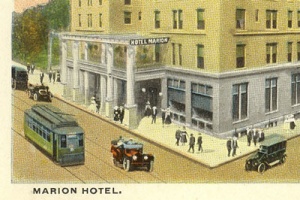
[[Image:Streetcar-marionhotel-postc.jpg|thumb|300px|Streetcar passing in front of the Marion Hotel in Little Rock.]] | [[Image:Streetcar-marionhotel-postc.jpg|thumb|300px|Streetcar passing in front of the Marion Hotel in Little Rock.]] | ||
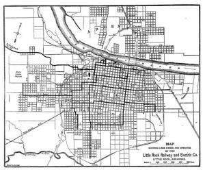
[[Image:Street-railway-1913.JPG|thumb|300px|Little Rock streetcar railway lines in 1913.]] | [[Image:Street-railway-1913.JPG|thumb|300px|Little Rock streetcar railway lines in 1913.]] | ||
Latest revision as of 10:55, 1 May 2011
The Little Rock River Rail comprises three separate electric trolley lines connecting major tourist destinations in the Little Rock River Market District of Little Rock, Arkansas, the Argenta Historic District of North Little Rock, the Clinton Presidential Center, and downtown hotels. The River Rail is administered by the Central Arkansas Transit Authority (CATA) and officially opened for public service on November 1, 2004. Little Rock is one of only ten cities in the country with an active electric trolley rail system.
There are currently 14 stops along the River Rail route: (1) Main at 5th, (2) Main at 7th, (3) Maple at 6th, (4) Maple at Broadway, (5) Alltel Plaza Stop at 120 Main Street, (6) Main Street Bridge, (7) President Clinton Avenue at Commerce, (8) Commerce at 3rd Street, (9) Clinton Presidential Center/Heifer International (World Avenue at 3rd), (10) 3rd at Commerce, (11) Historic Arkansas Museum (2nd at Scott), (12) 2nd at Center, (13) West Markham at Spring, (14) The Peabody Little Rock (Markham at Scott).
Day passes for riding the River Rail can be purchased at the following locations:
- Capital Hotel - corner of Markham & Louisiana (Little Rock)
- Main Library - 100 Rock Street (Little Rock)
- Courtyard-Little Rock Downtown - 521 President Clinton Avenue (Little Rock)
- Historic Arkansas Museum - 200 East Third Street (Little Rock)
- River Cities Travel Center - 310 East Capitol (Little Rock)
- City Services Building - 120 Main Street (North Little Rock)
- Baker House Bed & Breakfast - 109 West Fifth Street (North Little Rock)
- Argenta Bead Company - 703 Main Street (North Little Rock)
The construction cost of Phase 1 of the trolley system was $19.6 million, of which eighty percent was paid by federal grants. Phase 2 incorporated the Clinton Presidential Center and Heifer International headquarters into the trolley route with 2,600 more feet of track. Phase 2 replaced a temporary rubber-tire bus trolley painted to look like River Rail other streetcars. Phase 3 may include extensions to the Little Rock National Airport, Central High School, or the Arkansas State Capitol.
Little Rock Streetcar History
Mule-drawn trolleys operated in the city as early as 1877. The routes were electrified in the 1890s. Streetcar service ended in the city on Christmas Day 1947.
The Little Rock Street Railway and Electric Company had its origins in the Little Rock Street Railway Company founded on June 17, 1870. The company, under the leadership of W. E. Wright, was granted a franchise by Little Rock's city council to provide all horse- or mule-drawn rail transportation in the city. This first attempt to provide public transportation in the city immediately failed.
A second attempt in May 1873, under the name Little Rock Railway Company, went nowhere as the city denied the franchise request. Three more attempts by various companies failed to gain traction in 1876. In the spring of 1877 Little Rock approved Citizens Street Railway Company right-of-way for streetcar operations along Main, Center, Second, Markham, and Water streets terminating at the depot of the St. Louis, Iron Mountain, and Southern Railway. The company began running cars on the tracks on May 29, 1877. Two stables for mules were established at the corners of Seventeenth and Main street and at Ninth and Ringo streets.
In 1884 the Little Rock Street Railway Company was also awarded a franchise with the city and created four lines of its own. The City Electric Street Railway Company was granted a franchise in December 1887. This company received right-of-way permissions to all city streets not already allocated to horse-drawn competitors. The City Electric Street Railway first contracted with the Baldwin Locomotive Works in Philadelphia, Pennsylvania, to develop "dummy" steam engines to power its streetcars in Little Rock. The first steam service began on July 3, 1888.
The company was merged with the Citizens' Street Railway on April 1, 1890, and transferred to the Capital City Street Railway Company owned by Captain James H. Miller. The president of the new company was George B. Rose. The vice president and manager of Capital City was H. P. Bradford.
On March 3, 1891, the Capitol City Street Railway Company swallowed up all the franchises in the city and adopted the name of the City Electric Street Railway Company. City Electric had at this time twenty-two miles of track, forty-five streetcars, and 308 horses and mules. The company divested itself of its last animal power on November 22, 1891. Two days later it debuted the first of twenty-eight new electric streetcars. The Little Rock Traction and Electric Company incorporated on June 3, 1895, and took over all the lines in the city.
This company was replaced by a franchise called the Little Rock Street Railway and Electric Company on March 17, 1903. The company was formed from a merger of the Little Rock Traction and Electric Company and the Little Rock Edison Electric Light and Power Company. The new company was given a fifty year municipal electric railway franchise and a franchise for municipal lighting in perpetuity. The company issued one and a half million dollars in common stock. The president of the Little Rock Street Railway and Electric Company was D. H. Cantrell. By 1913 the company owned 32.3 miles of electrified track. The assets of this company were acquired by the Arkansas Central Power Company on April 10, 1923. Two years later Arkansas Central Power acquired eight double-end cars from the American Car Company. In 1927 the company purchased thirty Birney Safety Cars from American Car.
On April 10, 1923, the streetcar lines were taken over by the Arkansas Central Power Company. In 1925, the company purchased eight lightweight, double-end standard streetcars from the American Car Company in St. Louis.
In October 1926, the streetcar lines and power plant were taken over by the Arkansas Power and Light Company who then leased them to the Capitol Transportation Company. In 1927 this new company bought 30 single-truck, single-end lightweight Birney Safety Cars from the American Car Company. The cars, numbered from 300 to 329, were painted grey-green with red trim. A single Birney could carry thirty-three passengers. The regular fare in that year was six cents.
When the Fifteenth Street Line closed in the mid-1930s it became obvious that streetcar line expansions in the future were not likely. Arkansas Power & Light shifted its attention instead to increasing bus service capacity through its subsidiary Capital Transportation Company (CTC). Capital Transportation took over all streetcar operations in 1935, and ordered buses to replace car service on the West Fourth Line in North Little Rock and the Fifteenth Street Line in Little Rock. Within two years no streetcar service remained in North Little Rock. Also in 1937 CTC replaced the streetcars of the South Main Line and West Ninth Line with buses. By 1940 only the Pulaski Heights, South Highland, East Fourteenth, Fair Park, and East Ninth lines were served by streetcars. The last streetcar in the city ended its run from Fair Park on December 25, 1947.
Fare-Paying Passengers:
- 1909 - 9,365,476
- 1910 - 10,606,204
- 1911 - 10,985,874
Routes
The longest line in the system was the Pulaski Heights Line running from Main Street downtown to the White City (formerly known as Forest Park). This route was completed in 1904. Because the route to Pulaski Heights was steep, the railway required several switchbacks. Eight double-end lightweight cars purchased from the American Car Company in 1924 ran in this track. These cars were numbered from 400 to 407. A one-way ride over the complete route took approximately thirty minutes. The line operated a car barn inside Forest Park, which was originally owned by the railway company.
The South Main Line was a twenty-five block loop of track located downtown. At one end of the loop was the passenger station of the Missouri Pacific Railroad. Cars traveled from this station along Markham Avenue and then south onto Main Street. The Fifteenth Street Line was serviced first by Birney cars and then by the older double-end, double-truck streetcars. The Fair Park Line was double tracked along its entire length. It originally served West End Park (now occupied by Central High School, Kavanaugh Field, and Highland Park. The Biddle Shops Line left the South Main Line at the intersection of 21st and Main streets and continued east and south to Confederate Boulevard. The line had been constructed in 1914 for $35,925. Streetcars numbered in the 200s were used on this line. The West Ninth Line ran from Ninth & Main through the African-American business district of the city. The line followed High Street south to Braddock's Park (originally called Wonderland Park) on 35th Street. The line was no longer in operation by 1930. The Rock Island Station Line terminated at the Rock Island Railway Station. The South Highland Line deviated from the Fair Park Line at the intersection of Thirteenth and Woodrow streets. It followed Woodrow south to 19th Street before turning west and ended at Asher and 29th streets. The East Fourteenth Line turned off at Fourteenth and Main streets passed through the residential neighborhoods near old Little Rock High School and Oakland Cemetery. The line ended with a loop at Eighteen and College streets.
In North Little Rock streetcar service was originally provided by the Argenta Street Railway Company. Argenta Street Railway had been formed in 1906, and within eight years serviced about five miles of track in the city. In 1914 the company was sold to C. C. Kavanaugh and renamed the Intercity Terminal Company. The general manager of Intercity Terminal was A. R. Koonce. In 1924 the streetcar systems of North Little Rock and Little Rock were directly linked by the completion of track across the new Main Street Bridge.
The North Little Rock Main Street Line ran all the way up to 22nd Street. The line originally used a car barn at the corner of Eighth and Main streets, but when the connection to Little Rock was established the cars found shelter at the main car barn on North Street. All of the lines relied on cars numbered in the 100s and leased from the Little Rock Street Railway. The Washington Avenue Line stretched the system to Hazel Avenue. The Eighteenth-Pike Line connected the system to the railway shops of the Missouri Pacific Railroad and to bus stops taking passengers to Fort Roots and Camp Pike.
References
- "CATA Receives $5,977,603 Grant," Arkansas Democrat-Gazette, September 9, 2005.
- The City of Little Rock: Guide to the "City of Roses" for Visitors and Citizens (Little Rock, AR: Guide Publishing Company, 1890), 17.
- Clifton E. "Gene" Hull, "From Mule Cars to Buses," Arkansas Railroader 17.10 (October 1986): 7-15.
- Jennifer Barnett Reed, "River Rail: New Trolleys Serve Library Area," Arkansas Times, November 11, 2004.
- Jake Sandlin, "Bid for River Rail Extension OK'd," Arkansas Democrat-Gazette, October 19, 2005.
- McGraw Electric Railway Manual, vol. 20 (McGraw Publishing Co., 1913), 9.
- Shea Stewart, "Who's Riding the Rails?" Syncweekly, December 3, 2008.


