Saline County
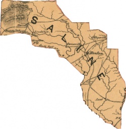
Saline County is named for large geologic salt formations found within the county borders. The county was formed on November 2, 1835, from portions of Hempstead and Pulaski counties. Neighboring counties include Pulaski County, Grant County, Hot Springs County, Garland County, and Perry County.
Contents
History
The vicinity was made famous for the buffalo salt licks found by members of the Hunter-Dunbar Expedition of 1804-1805.
Saline County was established on November 2, 1835. The county is famous for its rich mineral resources. Early salt works in the county supplied the precious mineral to places throughout the mid-south. Bauxite was discovered in June 1887 by state geologist John C. Branner, and the American Bauxite Company quickly bought up ninety percent of the deposits. The company built a large reduction plant at the company town of Bauxite, Arkansas, and shipped the resulting ore out of the state to East St. Louis, Illinois, for further refining into alumina, and eventually to Niagara Falls where the final aluminum product was produced by electrolysis. Other smaller players were Republic Mining and Manufacturing Company of Little Rock, Globe Bauxite Company of Chemical Spur, and the Du Pont Chemical Company. In the 1920s it was thought that seventy percent of the world's supply of the mineral was locked up in geological formations located in Saline and Pulaski counties between Benton and Little Rock.
The county is also famous for its pottery clays, especially kaolin deposits near Benton which are made into Niloak pottery.
Geography
Saline County, 725 square miles in size, is generally hilly and forested. The northwest corner of the county is managed by the U.S. Forest Service. Lake Winona is located on Ouachita National Forest land. Several branches of the Saline River flows through the county.
Transportation infrastructure
Interstate 30 passes through the county from the northeast to the southwest. Arkansas Highway 9 enters the county at the northern border, and passes through Paron before dead-ending at Arkansas Highway 5 in Crows.
Economy
The mineral resources of Saline County have long been important to the economy of the county. Salt exports were superseded in commodity value by bauxite. About 97 percent of the bauxite in the country was at one time mined in Saline County. Bauxite is used to make aluminum.
The largest employers in the county are the Bryant Public School District, Wal-Mart, the State of Arkansas, Saline Memorial Hospital, Benton Public School District, Landers Automotive, Birch Tree Communities, Rineco Chemical, CoorsTek, Rivendell Behavioral Health, Almatis, Sonic Drive-In, RGIS Inventory Specialist, Timber Ridge Ranch Neurorehab, and the Alexander Youth Service Center.
Law, government, and politics
The county judge is Lanny Fite. The county seat of Saline County is Benton. The Benton County Courthouse was used in the filming of parts of the 1972 film White Lightning starring Burt Reynolds.
Education
Saline County has five high schools: Bauxite High School (Bauxite), Benton High School (Benton), Bryant High School (Bryant), Harmony Grove High School (Benton), and Paron High School (Paron).
Religion
Places of interest
The Gann Museum of Saline County is constructed from bauxite boulders and contains exhibits on county history.
Demographics
According to the 2000 U.S. Census Bureau the population of the county was 83,529.
- 1980 - 53,088
- 1990 - 64,183
- 2000 - 83,529
- 2005 - 91,188
Communities
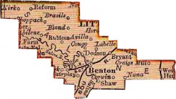
Saline County has a number of incorporated cities within its boundaries: Benton, Bryant, and Haskell. Incorporated towns in the county are Alexander, Bauxite, and Traskwood.
Other populated places in Saline County:
- Altharp (historical)
- Alum (historical)
- Avilla
- Bauxite Junction
- Bland
- Blocher
- Brooks
- Brooks (historical)
- Bryant Oaks
- Careywood
- Cold Springs (historical)
- Collegeville
- Congo
- Crows
- Cunningham (historical)
- Curtis (historical)
- Detonti
- Dirtdauber (historical)
- East End
- Edgewood
- Electric (historical)
- Evergreen
- Fairplay (historical)
- Gibbons (historical)
- Goodman
- Grape
- Hurricane (historical)
- Kentucky
- Klondike (historical)
- Lakeside
- Lena
- Lignite
- Nance
- Opitz (historical)
- Owensville
- Paron
- Pine Haven
- Raintree Acres
- Reform
- Richardson Place
- Rubicon
- Salem
- Sardis
- Shannon Hills
- Shaw
- Sherwood Estates
- Slocomb (historical)
- Springhill
- Tatumville (historical)
- Twin Oaks
- Vimy Ridge
- Whitlock (historical)
- Woodland (historical)
- Woodland Hills
References
- Dallas Tabor Herndon, The Highlights of Arkansas History (Arkansas History Commission, 1922), 133.
- State of Arkansas, Minerals in Arkansas: Including a Review of Oil and Gas Conditions (Ann Arbor: University of Michigan, 1922), 8, 42-46.

