Difference between revisions of "La Petite Roche"
| Line 1: | Line 1: | ||
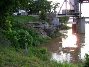
[[Image:La-petit-roche.jpg|thumb|La Petite Roche at the base of the Junction Bridge. Photo by sipes23 on flickr.]] | [[Image:La-petit-roche.jpg|thumb|La Petite Roche at the base of the Junction Bridge. Photo by sipes23 on flickr.]] | ||
| − | '''La Petite Roche''' ("The Little Rock") is the French name given to a rock formation located along the [[Arkansas River]] in downtown Little Rock. The outcropping was named by French explorer [[Jean-Baptise Bénard de la Harpe]] in 1722. De la Harpe was looking for a mountain or large rock in the region purportedly made of emerald. | + | '''La Petite Roche''' ("The Little Rock") is the French name given to a rock formation located along the [[Arkansas River]] in downtown Little Rock. The outcropping was named by French explorer [[Jean-Baptise Bénard de la Harpe]] in 1722. De la Harpe was looking for a mountain or large rock in the region called the "Green Rock" by the [[Quapaw Indians]] and purportedly made of emerald. Instead he found and named what is now known as [[La Grande Roche]] a few miles upstream from the Little Rock. |
It remains unsubstantiated whether Hernando de Soto camped near the rock in his 1541 expedition in the area. | It remains unsubstantiated whether Hernando de Soto camped near the rock in his 1541 expedition in the area. | ||
Revision as of 15:21, 18 July 2008
La Petite Roche ("The Little Rock") is the French name given to a rock formation located along the Arkansas River in downtown Little Rock. The outcropping was named by French explorer Jean-Baptise Bénard de la Harpe in 1722. De la Harpe was looking for a mountain or large rock in the region called the "Green Rock" by the Quapaw Indians and purportedly made of emerald. Instead he found and named what is now known as La Grande Roche a few miles upstream from the Little Rock.
It remains unsubstantiated whether Hernando de Soto camped near the rock in his 1541 expedition in the area.
La Petite Roche is often pointed to as the first visible rock beyond the alluvial plain in the Mississippi River system above the Gulf of Mexico.
The rock became famous as it was located near the main southwestern trail from St. Louis through the frontier region, and represented a relatively safe place to ford the river. The rock now forms the abutment of the Junction Bridge.
