Difference between revisions of "White Oak Bayou"
From FranaWiki
| Line 1: | Line 1: | ||
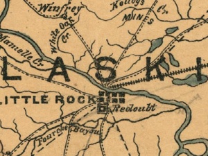
| − | [[Image:White-oak-bayou.JPG|White Oak "creek" northwest of Little Rock on c. 1864 Map of Arkansas & Louisiana by Helmuth Holtz.]] | + | [[Image:White-oak-bayou.JPG|thumb|300px|White Oak "creek" northwest of Little Rock on c. 1864 Map of Arkansas & Louisiana by Helmuth Holtz.]] |
'''White Oak Bayou''' comprises about forty-two square miles of watershed and fourteen hundred acres of wetland in [[Pulaski County]], Arkansas. The bayou lies mostly within the boundaries of [[Maumelle]] and [[North Little Rock]], and originates inside [[Camp Robinson]]. The bayou empties into the [[Arkansas River]] within the boundaries of [[Burns Park]]. | '''White Oak Bayou''' comprises about forty-two square miles of watershed and fourteen hundred acres of wetland in [[Pulaski County]], Arkansas. The bayou lies mostly within the boundaries of [[Maumelle]] and [[North Little Rock]], and originates inside [[Camp Robinson]]. The bayou empties into the [[Arkansas River]] within the boundaries of [[Burns Park]]. | ||
| Line 10: | Line 10: | ||
*[http://www.maumellewetlands.org/ Maumelle Wetlands Task Force] | *[http://www.maumellewetlands.org/ Maumelle Wetlands Task Force] | ||
| − | [[Category: Rivers and Streams]] | + | [[Category:Rivers and Streams]] |
Latest revision as of 15:05, 20 February 2010
White Oak Bayou comprises about forty-two square miles of watershed and fourteen hundred acres of wetland in Pulaski County, Arkansas. The bayou lies mostly within the boundaries of Maumelle and North Little Rock, and originates inside Camp Robinson. The bayou empties into the Arkansas River within the boundaries of Burns Park.
Natural areas in the watershed are characterized by mixed forest. Trees found in the forest include blackjack oak, bur oak, cherry bark oak, green ash, loblolly pine, overcup oak, post oak, shagbark hickory, short leaf pine, southern red oak, and willow oak. The bayou is populated with bald cypress and water tupelo.
