Difference between revisions of "Cadron Ridge"
From FranaWiki
| Line 1: | Line 1: | ||
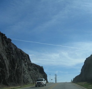
| − | [[Cadron-ridge-hogan.jpg|thumb|Hogan Road passing through Cadron Ridge in Conway, Arkansas. Photo by Phil Frana.]] | + | [[Image:Cadron-ridge-hogan.jpg|thumb|Hogan Road passing through Cadron Ridge in Conway, Arkansas. Photo by Phil Frana.]] |
'''Cadron Ridge''' is a geographical feature extending east-to-west from near Beebe, Arkansas, in White County to [[Cadron Settlement Park]], in [[Faulkner County]]. The ridge is transected at only a few points along its considerable length, including at House Gap, Hinson Gap, Carmichael Gap, Roden Mill Gap, and [[Cadron Gap]]. | '''Cadron Ridge''' is a geographical feature extending east-to-west from near Beebe, Arkansas, in White County to [[Cadron Settlement Park]], in [[Faulkner County]]. The ridge is transected at only a few points along its considerable length, including at House Gap, Hinson Gap, Carmichael Gap, Roden Mill Gap, and [[Cadron Gap]]. | ||
Latest revision as of 17:07, 9 March 2009
Cadron Ridge is a geographical feature extending east-to-west from near Beebe, Arkansas, in White County to Cadron Settlement Park, in Faulkner County. The ridge is transected at only a few points along its considerable length, including at House Gap, Hinson Gap, Carmichael Gap, Roden Mill Gap, and Cadron Gap.
The siting of Conway, Arkansas, depended in large measure on the location of Cadron Gap, which the Little Rock and Fort Smith Railroad used to avoid climbing the 150 foot ridge.
