Difference between revisions of "File:Conway-county-1864.jpg"
From FranaWiki
(Conway County in 1864. Map of Louisiana & Arkansas. Prepared under direction of 1st Lieut. Wm. Hoelcke, 39 U.S. Infty, acting Chief Engineer at hd. qts. Dept. of La., by Helmuth Holtz. Map public domain: http://memory.loc.gov/ammem/collections/civil_war_m) |
(No difference)
|
Latest revision as of 20:12, 26 February 2009
Conway County in 1864. Map of Louisiana & Arkansas. Prepared under direction of 1st Lieut. Wm. Hoelcke, 39 U.S. Infty, acting Chief Engineer at hd. qts. Dept. of La., by Helmuth Holtz. Map public domain: http://memory.loc.gov/ammem/collections/civil_war_maps/index.html
File history
Click on a date/time to view the file as it appeared at that time.
| Date/Time | Thumbnail | Dimensions | User | Comment | |
|---|---|---|---|---|---|
| current | 20:12, 26 February 2009 | 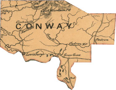 | 376 × 290 (32 KB) | Phil (talk | contribs) | Conway County in 1864. Map of Louisiana & Arkansas. Prepared under direction of 1st Lieut. Wm. Hoelcke, 39 U.S. Infty, acting Chief Engineer at hd. qts. Dept. of La., by Helmuth Holtz. Map public domain: http://memory.loc.gov/ammem/collections/civil_war_m |
- You cannot overwrite this file.
File usage
The following page links to this file: