Difference between revisions of "Pinnacle Mountain State Park"
| Line 1: | Line 1: | ||
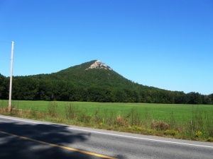
| + | [[Image:Pinnacle-mtn.JPG|thumb|Pinnacle Mountain. Photo by Phil Frana.]] | ||
'''Pinnacle Mountain State Park''' is a 2,000 acre "day-use" park located in west Little Rock, Arkansas. The Ouachita Mountain foothills park was dedicated in 1977 as the first state park near a major urban center. The park surrounds Pinnacle Mountain, a 1,011 foot cone-shaped peak visible from the I-430 bridge over the [[Arkansas River]]. The top of the mountain may be reached by the gently sloping, switchbacked West Summit Trail or by the steeply ascending East Summit Trail. The nearly level Base Trail runs around much of the southern and western base of Pinnacle Mountain. These trails connect to the 223-mile [[Ouachita National Recreation Trail]], and will eventually connect with the [[Arkansas River Trail]] which runs on both sides of the river all the way to downtown Little Rock. | '''Pinnacle Mountain State Park''' is a 2,000 acre "day-use" park located in west Little Rock, Arkansas. The Ouachita Mountain foothills park was dedicated in 1977 as the first state park near a major urban center. The park surrounds Pinnacle Mountain, a 1,011 foot cone-shaped peak visible from the I-430 bridge over the [[Arkansas River]]. The top of the mountain may be reached by the gently sloping, switchbacked West Summit Trail or by the steeply ascending East Summit Trail. The nearly level Base Trail runs around much of the southern and western base of Pinnacle Mountain. These trails connect to the 223-mile [[Ouachita National Recreation Trail]], and will eventually connect with the [[Arkansas River Trail]] which runs on both sides of the river all the way to downtown Little Rock. | ||
Revision as of 18:15, 28 September 2008
Pinnacle Mountain State Park is a 2,000 acre "day-use" park located in west Little Rock, Arkansas. The Ouachita Mountain foothills park was dedicated in 1977 as the first state park near a major urban center. The park surrounds Pinnacle Mountain, a 1,011 foot cone-shaped peak visible from the I-430 bridge over the Arkansas River. The top of the mountain may be reached by the gently sloping, switchbacked West Summit Trail or by the steeply ascending East Summit Trail. The nearly level Base Trail runs around much of the southern and western base of Pinnacle Mountain. These trails connect to the 223-mile Ouachita National Recreation Trail, and will eventually connect with the Arkansas River Trail which runs on both sides of the river all the way to downtown Little Rock.
The park address is 11901 Pinnacle Valley Road in Little Rock.
