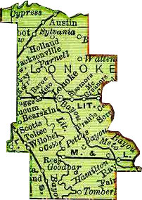
Lonoke County
Lonoke County was created in 1873. The county was named for a very large red oak tree stood alone at the site of the county seat of Lonoke ("Lone Oak"). Neighboring counties include White County, Prairie County, Arkansas County, Jefferson County, Pulaski County, and Faulkner County.
Contents
History
The county was formed on April 16, 1873.
Geography
Lonoke County, comprising 766 square miles of territory, is mainly agricultural. The southeastern part of the county is drained by the Bayou Meto and Two Prairie creeks.
Transportation infrastructure
Interstate 40 passes through the central part of the county from east to west. The interstate is paralleled by U.S. Highway 70. U.S. Highway 67 passes through the northwest part of the county. U.S. Highway 165 enters the county from North Little Rock at Scott, passes southeast through Keo and England, then heads due east through Coy, Allport, and Humnoke.
Economy
The largest employers in Lonoke County are the Cabot Public School District, Remington Arms Company, Wal-Mart, Lonoke Public School District, England Public School District, McDonald's, Sonic Drive-In, Golden Years Manor, Knight's Super Food Store, Kroger Food Store, Bank of England, and the Carlisle Public School District.
Law, government, and politics
The county judge is Charlie Troutman. The current Lonoke County Courthouse was constructed in 1928, the two previous courthouses having been destroyed by fire.
Education
Lonoke County has four high schools: Cabot High School (Cabot), Carlisle High School (Carlisle), England High School (England), and Lonoke High School, Lonoke.
Religion
Places of interest
Places of interest include the Lonoke County Courthouse Square, Toltec Mounds State Park, the Smoke Hold Natural Area, and Joe Hogan Fish Hatchery.
Demographics
According to the U.S. Census Bureau the 2000 population of Lonoke County is 52,828.
- 1980 - 34,582
- 1990 - 39,268
- 2000 - 52,828
- 2005 - 60,658
Communities
Lonoke County has a number of incorporated cities within its boundaries: Austin, Cabot, Carlisle, England, Humnoke, Lonoke, and Ward. Incorporated towns in the county are Allport, Coy, and Keo.
Other populated places in Lonoke County:
- Bailey Addition
- Bailey Estates
- Bayou Meto
- Bel-Aire Subdivision
- Bevis Corner
- Blakemore
- Boyd (historical)
- Brownsville
- Brummitt
- Butlerville
- Camelot Acres
- Camilla (historical)
- Candlewood Estates
- Castle Heights
- Cedar Hills Estates
- Cinnamon Acres
- Circle B Addition
- Cobbs
- Confederate Place
- Cooper Addition
- Country Club
- Country Club Addition
- Country Lane
- Country Road Estates
- Crestwood
- Culler
- De Boer
- Deer Creek Subdivision
- Dogwood Meadows
- Eagle Park (historical)
- Evans Estates
- Evergreen Place
- Fulmer Field Estates
- Furlow
- Geridge
- Glenwood Estates
- Greyhawk Addition
- Hamilton
- Hamiter
- Hidden Oaks
- Holland
- Hoover Addition
- Kelly Addition
- Kemp Addition
- Kerr
- Kingwood Addition
- Leaning Pines
- Lincoln Terrace
- Lindulake Addition
- Mark Lynn Terrace
- McCreanor
- McDermott Addition
- Meadowlark Addition
- Meto
- Meto (historical)
- Mount Carmel Estates
- Mount Springs Estates
- Mountain Springs
- Oak Forest
- Oak Grove
- Oakridge Estates
- Old Austin
- Opal
- Parkers Corner
- Parnell
- Pershing Addition
- Pettus
- Pheasant Run Addition
- Pine Hill Estates
- Pinewoods Addition
- Poage Addition
- Prairie Center
- Ridgecrest
- Ryan
- Scott
- Seaton
- Seaton Dump
- Sellers Addition
- Shadow Oaks Addition
- Shady Grove Estates
- Sisemore
- South Bend
- Southbridge Addition
- Southside Addition
- Southwood Addition
- Spring Valley
- Stagecoach Addition
- Summit Addition
- Sunland Estates
- Sweetwater Estates
- Sylvania
- Talbot Addition
- The Heights Addition
- The Meadows Addition
- The Oaks
- TKO Subdivision
- Toltec
- Tomberlin
- Tower Hill Addition
- Trailwood Addition
- Union Valley
- Vise Addition
- Wabbel
- Walkers Corner
- Waterproof
- Wattensaw
- Waymack Addition
- Welders Wood
- Whispering Pines Addition
- Whisperwood
- Wildwood
- Willow Belle
- Willow Lake Subdivision
- Windwood Circle
- Windwood Heights
- Woodiel Acres
- Woodlawn
- Woodlawn Addition
- Woodlawn Estates
- Young Subdivision
